Dec 31, 2017

The New Year's Weather

The new year is going to start the same way that the old year ended - FRIGID ! First let's look at some of the climatology for New Year's Day for both Albany and Glens Falls:


New Year's Day Climatology
ELEMENT GLENS FALLS ALBANY
WARMEST TEMP
66°/2007
57°/1966
WARMEST AVG.
57.5°/1950
46.5°/1966 and 1979
LOWEST TEMP
-7°/1957
-18°/1970
LOWEST AVG.
-18.5°/1994
-3.5°/1918
WETTEST
2.55"/1999
0.95"/1935
SNOWIEST
15.7"/1986
9.2"/1961

Temperature records go back to 1874 for Albany and 1944 for Glens Falls. Regarding snowfall for Glen's Falls, snow observations ceased at the site in 2003 when the site went to an automated observation system . However, I do not recall any heavy snow on New Year's Day since then.


New Year's Day 2018 Forecast


It will be frigid for both locations. In spite of abundant sunshine highs in Albany will be near 10° and for Glens Falls highs in the lower single numbers to near 5°. From the NWS in Albany, only 3 New Year's Day had a high temperature less than 10°. 2018 looks like it might be the 4th time for such an occurrence. In addition to the frigid air temperatures wind chills will make it feel colder thanks to a gusty NW wind. Daytime wind chill temperatures will range between -15° and -10°. The first night of 2018 will see readings to dip to -5° at Albany and -20° at Glens Falls which would be a record low temperature for this location.

Forecast for the rest of 1st week of 2018


A bit of thaw is expect during the Tuesday into early Thursday period. Highs will make it into the mid teens on Tuesday in both Albany and Glens Falls. On Wednesday even a bit more of warm-up low 20s for Albany and near 20° for Glens Falls. (Let's have a barbecue and breakout the shorts!). As for Thursday expect highs near 20 or low 20s in Albany and mid to upper teens for Glens Falls.

Also during Thursday through Friday a large storm is forecast to be moving north across the western Atlantic.  At this time it looks like it will be too far east to cause us any significant snow.

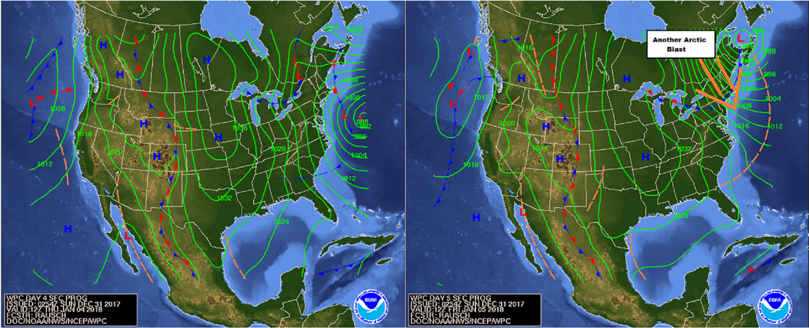
However, the large circulation around the storm will cause a strong NW-N airflow  to develop around its western perimeter. This flow of air will be from the arctic reaches of Canada so by the Friday into the next weekend we'll likely see (hard to believe) the coldest weather of this young winter season. It looks like more daytime highs in the digits or near 0 ° and widespread well below zero readings are likely during the nights. I can see the potential for readings near -20 to -25° Friday, Saturday and maybe next Sunday night at Glens Falls and across the Southern Adirondacks.

Deep Freeze

A deep freeze as defined by the National Weather Service is when the high temperature does not get above 32°. The longest stretch for Albany  where the high never got past the freezing mark was 36 days. This deep freeze spanned the period from January 5 to February 9 in 1945. Temperatures records for Albany go back to 1874. During this time period there have been dozens of deep freezes of varying length. The number of deep freezes that met the minimum 10 consecutive days is 18; the last deep freeze was in 2014, from February 25th to March 6th. 

The last time Albany got above 32 ° was on Christmas Day. So for Albany through the 31st of December it will be 6 days with a high temperature < 32°.  Glens Falls is on a 7 day stretch.  When you look ahead to the upcoming first week and weekend of 2018 and the expected temperatures, we can say with high confidence that we will be in a "Deep Freeze".  This extreme cold could last into the following week, too. 

Some longer range data indicates the possibility for a break around mid-January. By then we could see more seasonable temperatures. Something to look forward, to. Something I am not looking forward too is my heating bill that should be arriving this week!

References:

Climate date for New Year's Day and Deep Freeze dates courtesy of NWS Albany, NY

Climate Data for Glens Falls extracted from The Northeast regional Climate Center (NRCC) 
database 

Forecast maps from Weather Prediction Center (WPC)

Dec 28, 2017

More Cold - er Weather On The Way

(Fig.1) image from: www.geography.hunter.cuny.edu
   Since the source of arctic air is from near or within the snow and ice covered areas of the Arctic Circle (Fig. 1), it will be very dense and very dry. As it advances south and southeast from its source region it would tend to modify as it passes across a warmer land mass beneath it.
 (Fig.2) 28 Dec 2017 Snow on the Ground courtesy:

   However, thanks to an extensive snowpack across the interior parts of the Northeast and Great Lakes States north across Southern Canada (Fig.2)  this air will modify VERY little. Thus, we can expect the very cold weather to continue into the new year. Through New Year's Day we can expect bitter cold high and low temperatures to persist averaging about 25° BELOW normal.

   In addition, whenever we have even a slight breeze or stronger expect dangerously low wind chills to occur. Such will be the case through early tonight and again later Friday into Saturday (when it will be more of stiff wind vs. a gentle breeze). We'll also have more clouds on Friday through Saturday along with the chance for some periods of light snow or snow showers as a clipper moves through. With this low's passing brisk N and NW winds will kick in later Saturday along with a re-enforcing shot bitter and frigid air moving in for New Year's Eve and New Year's Day.

   There is very little change to the temperature forecast through 2 Jan; The "relatively" warmest day will be on Saturday when temperatures will make into the teens (perhaps some 20° or low 20s south of Albany). Otherwise, daytime highs will be in the single numbers to 10° and nighttime lows well below zero.

   Last but not least...there is the chance for a snowfall next week in the Wednesday through Friday period. I am already getting messages and emails regarding this possible snowfall. All I will say is that there is a possibility for snow. As is always the case track, intensity and speed of the storm (aka duration) will determine what we get or don't get. Be prepared for a lot of postings on this possible "storm" on Facebook, Twitter, Google+ or wherever else they are posted, to.

   Remember: check the SOURCE of the post. If its just a map of some model's snowfall forecast I would discount it. ANYONE can post a map of some computer forecast model without having any knowledge of what they are posting. SHARE any posts responsibly, too. Finally, please don't ask me about what "others" are saying we're going to get. I can only speak for myself. Obviously I'll have more on this over the days to come. Hope everyone is staying warm.

Dec 26, 2017

Arctic Cold Wave on the Way

Starting tonight arctic air will sweep down across the region. Over the next 7 days re-enforcing "shots" of arctic air will help to replenish the frigid air over us.

The 6-10 day and 8-14 day temperature outlooks from the Climate Prediction Center (CPC) indicate a high probability for below normal temperatures from today thru 18 January 2018.


How cold will it get? Well the average high for Albany through the end of this month is 32° and for Glens Falls its 29°.  I'm forecasting high temperatures on Wednesday in the mid to upper teens for both of these locations locations.  For the Thursday through next Monday (New Year's Day)  forecast highs for  Glens Falls will only be in the mid and upper SINGLE numbers while Albany's highs will be near 10° or 12°.  In addition there is a very high probability for widespread SUB-ZERO nighttime temperatures in many locations over the next several nights, too. The last time Albany had a minimum temperature BELOW 0° was February 15th 2016. (Glens Falls has already had 2 days with low temperatures below 0° this month).

An if these very cold temperatures weren't bad enough when combined with periods of gusty winds in the forecast (like for tonight and Wednesday (Dec 27th)  you can expect it to feel even colder , Expect wind chills ranging from -10° to -25°, with some of the higher terrain perhaps getting to -40°!  Additional periods of blustery conditions late Thursday and again later Saturday into next Monday could result in more periods of extremely low and DANGEROUS wind chill conditions.

Stay warm! Remember to not leave your pets outside in the cold.


Dec 20, 2017

Meteorological Memories

   I was sort of "shamed" into cleaning up my office AKA my "man cave" by my daughter. She remarked about how cluttered and messy it looked with all the vanilla folders, loose-leaf binders and books, strewn about the room both on my makeshift coffee table, desks (I have two of them in the room) and on the various shelves and storage bins that I also have in the room.

  She asked, "When was the last time you read or used that 'stuff'' ?  Some of it looks like it is ancient!"  I then  paused and realized she made a  valid point.  (Okay, she was right.) So I began the massive cleanup (which I really did intend on doing along but my usual procrastination prevented me from doing so until now).

  Some of these papers and booklets were indeed old! They were memories from my days as an "amateur" meteorologist. In the folders and binders are pamphlets and booklets that I purchased from the U.S. Government Printing Office in Washington, D.C. when I was 9 and 10 years old! (That makes them  over 50 years old!!) For sentimental reasons I have kept them (and will keep them). In many ways these and all my other papers and books in my weather collection are my personal weather history of my years in weather AND also a history of the field of meteorology, itself.

  What was in these folders and binders ? Some contained AMS Meteorological monographs, others had books, pamphlets and articles on assorted topics in meteorology (and oceanography, too which I studied as well, when I was in college).  Some of the books and articles dealt with short and long range weather forecasting. Others were on topics like tropical meteorology and or hurricane forecasting. It was hurricanes  taht got me interested in meteorology. It was my faint recollections of Hurricane Donna that peaked my interest in weather.

  Other papers in my collection dealt with topics such as: atmospheric (planetary waves), severe weather, winter weather case studies and forecasting of such for various parts of the U.S. including the Northeast. Some of these papers were from my college days back in the early 70s. They were required reading for my studies; some of the more recent ones were procured for personal research for projects that I either did or intended to do (and still hope to do). I also found my two research papers that I did on severe weather for the area: One on the Mechanicville Tornado that occurred in May of 1998 and the other on an early morning severe weather event (and a rare November tornado in Columbia county) over Eastern NY State. The former paper I presented at the Northeast Storm Conference in Saratoga Springs in March 1999.

  Enough of the reminiscing. Onto my "cleaning" project and my dilemma: What do I toss and what to keep?  First I began condensing 'stuff'. I organized my binders into topics and then placed the articles that matched the topic into a LARGE loose leaf binder. My "tropical" weather folders were far and away the most in number. So I threw out a lot of papers, articles and booklets, especially articles from the 60s and even 50s. However, I did keep a couple from this "era". There was a paper on Hurricane Donna and its two eyes. This paper was procured for me by a very special and dear  friend who knew how this hurricane started me on my road to my career in meteorology.

   Tied for second place in the bloated folders and binders category were my severe weather and winter weather forecasting ones. Some of the papers were from the 1970 and earlier. Some of them were "old school" forecast techniques that are now no longer used (much). I at least for now can still recall the techniques and use them today if needed. Regardless, I threw many of them away.  I also realized that  in some cases, I had duplicates and even a few triplicates of articles and research papers.  No sentimentalism here- this is an easy decision, toss them out!

  The project that I was "shamed" into doing is now near complete, at least as far as the condensing goes.   I lost track of how many vanilla folders I discarded  in my cleaning but I do know I know that I now  have 18 loose-leaf binders that I was able to clear out completely. (If anyone needs loose-leaf binders, let me know I'll give you a better deal than Staples!)

  This project got me reminiscing of my days as a "amateur" weatherman. Definitely this will be another blog post in the not too distant future.

[I will be adding some photos soon!]