Areas to the west by north of Albany will see mostly snow and the higher elevations will easily see a foot of snow, if not more, thanks to the combination of elevation and colder temperatures along with upslope winds enhancing already strong lift.
Here is a comparison of this morning's 7 AM models from various national and international meteorological centers. Maps are from www.meteocentre.com

The maps to the left are initial panels for the 4 main forecast models valid for 7 AM this morning (8 Dec). Clockwise from upper left to lower left your are looking at the CMC Global of GEM model, to the right is the US GFS model; bottom right is the UKMET office model and lower left is the European of EC model. The contour bands are the upper air contours for the 500 hPa level and thr black lines are the surface isobar.

The maps to the right are the forecast charts for the surface and upper-air valid for Wednesday morning 7 AM, 9 December 2014. All of the models are in very good agreement as to placing an intensifying low near or just off of the Mid-Atlantic coast. They all also show a strong "blocking" area of high pressure over Newfoundland. As you will see on the following forecast maps, this high remains nearly stationary. Thus the coastal storm cannot move quickly and this is why this storm will be a long duration event for the region.

The maps to the left are the forecast surface and aloft (500 hPa) for Wednesday morning 7AM December 10th. The UK and EC (bottom row of maps) have the low very close to Islip Long Island. The GFS upper right has the low near the South Shore of Long Island (south of Islip) while the GEM (upper left) has the low over New York City. Comparing the forecast maps from Tues morning to Wednesday morning you can see that the low both intensifies and moves very slowly while the high retrogrades west to over Quebec Province.

The maps to the right are the forecast maps for Thursday morning December 10th. The top two maps are from the GEM and GFS and both indicate the low lifting north toward Canada or Northern New England and weakening. The EC and UK indicate the low weakening but still lingering over south-central New England. For the past three days the EC and UK have been very consistent in their model output. For the forecast that follows, I have heavily leaned on these two models.
The following map is the cyclone track map for the UK.
 |
| UK Cyclone Track comparison last 2 runs |
The EC is very similar, too. During the late fall and winter with a low forecast to track very close to the East Tip of Long Island more often than not Eastern NY State winds up with heavy precipitation; if t is cold enough this precip falls in the form of snow. With the high retrograding in time cold air will persist to the north and west of Albany and this will allow for predominantly snow to fall. With a low near Eastern Long Island warmer air especially aloft should result in snow mixing with or changing to rain and sleet to the south and southeast of Albany with a snow sleet rain mix up through the Berkshires, Capital District and the Eastern Mohawk Valley and Southern Saratoga County
For now here is what watches and warnings have been posted by the NWS:

The winter storm watch has been upgraded to a warning in places (lavender color regions). NWS is keeping the watch up for the Mid and Upper Hudson River Valleys and points east and has now added a Winter Weather Advisory for areas to the south through southeast of Albany. The flood watch remains in effect for the Lower Hudson Valley and NW Connecticut.
Storm Details
STORM HAZARDS:
Heavy precipitation:
Heavy snow: across the Catskills and Hilltowns and Southern Adirondacks where accumulations will exceed 12 inches.
Heavy Rain: Lower Hudson Valley and NW Connecticut after a period of accumulating snow. Potential small stream and urban flooding
Wind:
Periods of gusty East winds with gusts to 40-50 mph possible across the higher terrain of the Catskills, Taconics, Berkshire and Green Mountains during Tuesday could cause blowing snow and perhaps some sporadic power outages.
START TIME: Daybreak Tuesday over the Lower and Mid-Hudson Valley, Capital District between 9AM and Noon with areas north of the CD between Noon and 3 PM

Cyclogenesis of the expected Nor'easter
While not unprecedented it is not too often that a low to develops well of the East Coast and then moves northwest toward the coastline before turning to the north or northeast and head toward New England.
East Coast cyclones (low pressure systems) of a non-tropical nature are classified into three main groups. Miller A and Miller B systems as documented by J.E. Miller. Its a simple classification scheme: Miller (type) A lows develop over or on the Southeast US Coast or Gulf of Mexico often on stalled or slow moving cold fronts.
Miller (type) B lows can develop over the region from the Mid-Atlantic Coast to the New England coast. These are called "secondary lows". They form in association with an area of low pressure moving across the Lower Great Lakes or Ohio Valley. The low to the west is usually filling and the secondary low redevelops to the east usually on the primary low's warm front or at the "triple point" of the primary low - that is the point where occluded, cold and warm fronts meet.
The last type of low - which is how tomorrow's Nor'easter has developed is called a "blocked low". This not too common of how a Nor'easter forms. This type of development has been documented by James Andrews in an article from Mariners Weather Log. Te low development sequence occurs when a strong high pressure area is over Canada, the Maritimes or Northern New England. The low develops well off the coast over warm Atlantic Ocean waters.
Due to the high "blocking" the low from continuing on an out-to-sea track, the low turns west or northwest around the high towards the East Coast.
Intensification of the low is possible as it moves across the Gulfstream waters as well as additional energy that exists because of the strong temperature contrast during the cool season between the chilly land and the warmer ocean. Last, when a strong upper-air trough approaches from the west this further aids in the intensification process. From Andrews' article in the Mariners Weather Log Look for the following to happen at the surface:

Here are surface and upper air analysis for 7 AM 8 December 2014. The surface map shows a weak low well offshore to the east of the Carolina's Coast.
The 500 hPa map shows the approaching upper-air disturbance (dashed line over Central US) that will aid in the offshore storm's intensification.
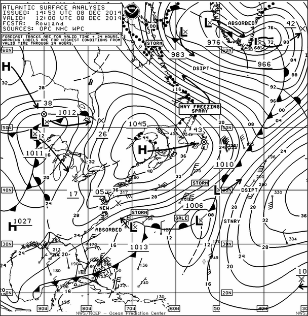 |
| 7 AM 8 Dec 2014 EST Surface map |
 |
| 7 AM 8 Dec 2014 EST 500 hPa analysis |
 |
| Fcst surface map 7AM EST Tues 9 Dec 2014 |
 |
| Fcst 500 hPa chart 7AM EST Tues 9 Dec 2014 |
By Wednesday morning 10 Dec a strong Nor'easter is near the NJ coast
 |
| Fcst Surface Map 7 AM EST Wed 10 Dec 2014 |
 |
| Fcst 500 hPa chart 7 AM EST Wed 10 Dec 2014 |
References:
J.E. Miller, "Cyclogenesis in the Atlantic Coastal Region of the United States", Journal of Meteorology, Vol 3, No. 2, June 1946
J.F. Andrews, "Cyclogenesis Along the East Coast of the United States", Mariners Weather Log, Vol.7, No. 2, pp. 43-46
