
Rainfall totals over the past 3 weeks (since May 21st) are impressive: For NY State Albany has recorded 9.02", Glens Falls 6.71" and Poughkeepsie has measured 6.95". Bennington, VT has recorded 10.84"" over the past 3 weeks while Pittsfield, MA having an estimated 9.30".
This area is not alone in the above normal rainfall parade. Through the first 11 days of June rainfall totals across PA, DE and NJ have already placed some locations in the top 10 wettest June's of record: Philadelphia 6.79" (10th wettest June; record is 10.06" set in 1938). Wilmington, DE 7.13" (7th wettest June; record is 9.90" set in 2003). Rainfall in this region is about 200%-400% ABOVE NORMAL for June alone !
What's heading our way
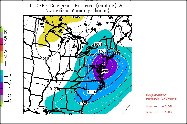
An anomalously STRONG storm system laden with moisture; the low pressure system that is forecast by ALL numerical weather data suites and ensembles to move across the Eastern U.S. will be a rare event. The intensity of the low will be near 990 millibars when it nears the Mid-Atlantic Coast. Here is the forecast surface map (on the left) for Thursday evening 13 June 8PM on the right is the pressure anomaly. For this time of year the low pressure system will have a standard deviation (SD) of -4 to -5. This is significant for just about anytime of year let alone for June!

Other anomalies of significance are the precipitable water (PWAT) map on the left and the anomalous component of the 850 hPa wind. PWAT anomalies are +2 to +4 SD above normal while the easterly component of the 850 hPa wind is near -5 SD.


This strong easterly wind aligned over the area will advect in a lot of moisture from off the Atlantic Ocean and also aid in enhancing lift especially across the east facing slopes of the Catskills, Taconics, Berkshires and southern Green mountains.
How much rain?
As of now the potential rain fall for the region looks to be around 2" with potential for near 4" amounts to the south through east of Albany (this includes the Central and Southern Catskills, Taconics and Berkshires). Because of the antecedent wet weather conditions over the past 3-4 weeks the ground is saturated, the water table as well as many streams and rivers are higher than normal for this time of year. Thus rainfall amounts of 2-4 inches will cause flooding. We will continue to monitor all the latest data and keep you posted.
An aside on tomorrow's storm
For folks across Virginia, Maryland, Delaware, Southern NJ and SE Pennsylvania tomorrow could prove to be a dangerous day as the potential is quite high for a widespread and MAJOR severe weather outbreak including very high damaging winds perhaps 75mph or more, large hail and possible strong tornadoes.
No comments:
Post a Comment