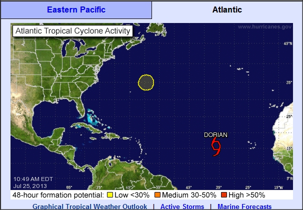
99L is a weak surface low associated with a stalled front well off the East Coast and an upper-air low aloft. It is in a rather "complex" atmospheric environment but it is located both south of the Gulfstream and over warm water with SSTs at 26°C or warmer. The latest visible satellite loop for 99L shows a low-level cloud swirl near 35.2°N60.3°W but the higher top convective clouds are displaced to the north by east of this low level circulation by a distance of 45 miles or greater. The satellite signature has what I call a "thumb" look to it (place your thumb over the cloud mass you'll see what I mean), such a signature is associated with a weak, disorganized system and it is also an indicator of unfavorable shear over it. This noted, winds aloft are forecast to become more favorable for some development of this feature. While it is currently moving NNW it will turn N and then NE over the next 48 hours as it moves northeastward AWAY from the US coast. In a couple of days it will be moving over cooler SSTs which are a nemesis to tropical systems, thus weakening is expected.
As for Dorian it continues to hold its own. At 11 AM EDT it was located approximately 1800 miles to the east of the Northern Leeward Islands. It continues to rip along toward the WNW at about 18 mph as it remains south of the Atlantic subtropical high to it its north
 |
| Mean steering flow 850mb-500 mb Dorian located by RED X and ST high denoted by the light blue "H" |
Maximum winds are 60 mph and Dorian has now moved past the region of cooler SSTs but it is in an area where the atmosphere is drier and should be in this environment for about the next 24-36 hours. While the official NHC forecast calls for some slight weakening during this time, I would not be surprised if it held steady in strength or even increased in intensity due to both the shear being less than forecast yesterday (on the order of 10-15 knots) and also the possibility for a poleward outflow channel developing over the system due to a "smaller" HIGH aloft over the tropical Storm.
To the right is a map of Dorian's location and track for the next few days with satellite derived/observed winds overlayed. The yellow wind barbs are for the high levels of the atmosphere between the 350 and 250 hPa levels. Note the anticyclonic (clockwise) flow at this level. High pressure areas aloft above a tropical cyclone are "favorable" for development.
 As for he official NHC forecast track it has not wavered over the past day or so. A continued WNW motion is expected with a gradual decrease in its forward speed.
Barring any changes to the over all weather pattern across the Atlantic and to Dorian itself it would appear that the storm would pass north of both The Lesser Antilles, Puerto Rico and the Virgin Islands by late Sunday or early Monday of next week. It will also be passing to the south of the Hurricane Benchmark position of 25°N60°W; this is critical because storms that pass over or to the south or west of this point on a W, WNW or NW heading can pose a threat to the East Coast of the US. This threat can range from peripheral ones like rough seas and high long period swells and even rip currents to more serious impacts like heavy rain and or wind. Let me reiterate that I am NOT saying Dorian WILL MAKE landfall along East Coast, a lot can happen between now and next week, but if the trends continue as they are we will definitely have to watch this system.


No comments:
Post a Comment