Our wet weather pattern can be tied to an abnormal upper-air pattern called a block that persisted across North America, from the Central Pacific to the central Atlantic. An atmospheric "block" is when weather systems, usually high pressure cells become very large in size both at the ground and aloft. Thus they tend not to move or move very little. Blocks cause "persistence" type weather; that is depending on what part of the block you are located your weather can either be dry or nice, or unsettled.
Normal mid-June Weather vs Mid June 2013 actual weather
First let's look at the upper-air pattern for the period June 15th through June 30th. Here is what the "normal" 500 hPa constant pressure chart (approx 18,00 feet ) above the ground would look like for this period:
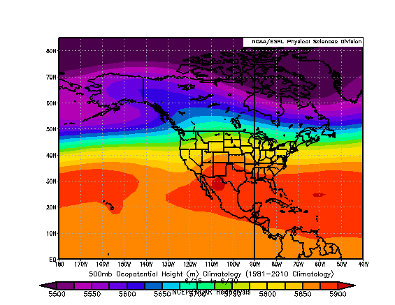 |
| Normal 500 hPa heights for period 15th-30th June |
A constant pressure chart is are really a topographic map of the atmosphere. The height lines or contours indicate how high above the ground the pressure of in this case 500 hPa is observed. The higher the height at this level (in the case of the colors the brighter yellows to oranges and reds) the higher up one must go to record a pressure of 500 hPa; these contours indicate HIGHER pressure aloft. Conversely the cooler colors down to the purples indicate LOWER pressure aloft. So normally during the period of June 15th through 30th. A large area of high pressure (aloft) prevails across much of the Lower 48 states with the jetstream north of the International Border. The very brighter oranges and reds over both the Atlantic and Pacific Oceans are associated with the semi-permanent subtropical high pressure cells. The contours can also approximate the wind flow too. The winds tend to blow parallel to the contours. So a general west to east wind ("zonal" flow) would be the expected norm for this period.
Now lets take a look at the anomaly of the 500 hPa for June 15th-30th, 2013(map below). It shows how the weather pattern for the last 15 days of June 2013 deviated from normal ( that is how it deviated from the "normal" chart shown above).
 |
| 500 hPa Composite Anomaly for period June 15-30, 2013 |
The darker colors indicate lower than normal "heights", while the brighter greens to yellows and reds indicate higher than normal heights. From this chart we can infer the following: across Texas and the Southwest States through the Rockies and High Plains and over the Atlantic to the east of New England and the Canadian Maritimes there are two areas of HIGH pressure which averaged out stronger than normal for this time period. Between these two systems we have an elongated trough of low pressure aloft (strongest over) from Quebec Province extending southwestward across NY State to the Ohio Valley. Again we can use the anomaly contours to approximate wind flow; Thus to the west of the Atlantic anomaly and also to the east of the trough over Canada and the U.S. we have a southerly flow of air. These two features acting together were able to pull very moist tropical air from out of the Gulf of Mexico and Atlantic over the Northeast States.
Below is a chart for normal values of precipitable water (pw) for the period 15th-30 June.
 |
| Normal precipitable water (pw) for period 15-30 June |
Now let's look at the pw anomaly for June 15-30, 2013. This chart shows that during the last 15 days of June 2013 pw values were 2 to 4 standard deviations above normal.
 |
| pw anomalies for June 15-30, 2013 |
Thus any low pressure systems or disturbances that affected the area would be capable of producing HEAVY rainfall.
 |
| Anomaly of surface pressure for period June 15-30, 2013 |
The normal sea level pressure map for this period would feature relative high pressure for much of the eastern half of the United States. However for the period of June 15-30, 2013 as shown in the map above, a large area of BELOW (-2 to -3) sea-level pressure anomalies extended from the Texas Panhandle northeastward across the Upper Midwest, Great lakes, Ohio Valley and the Northeast states. It was within this region of below normal surface pressure that several low pressure systems formed and/or tracked. These disturbances lead to the periods of heavy rainfall.
What is in store for the start of July
Here are the initial surface maps and 500 hPa charts from the July 3rd 8PM EDT computer models:
 |
| Initial Model Conditions for 3 July 2013 8PM EDT |
The black lines are isobars (surface pressure) and the colors are height contours for 500 hPa.
Below is the forecast from the various computer models for 8PM July 4th.
 |
| 48 hour forecasts from GEM-GBL'GFS/ECMWF/UKMET models valid for July 4th, 2013 8PM |
Compare the red areas on these forecast maps to the initial model conditions. The forecast data is indicating that the blocking weather pattern is both (slowly) weakening and retrograding or if you will shifting to the west. The trough aloft is forecast to shift to the center of the nation while the offshore high gradually builds over us. As this high begins to increase its influence on our weather we should see decreasing rain threats over the next 4-5 days; any rain that does occur will be rather scattered and perhaps locally heavy, in addition our temperatures will be warming up too with the chance for some 90° + days through the upcoming 5 days or so.
No comments:
Post a Comment